| Contact |
|
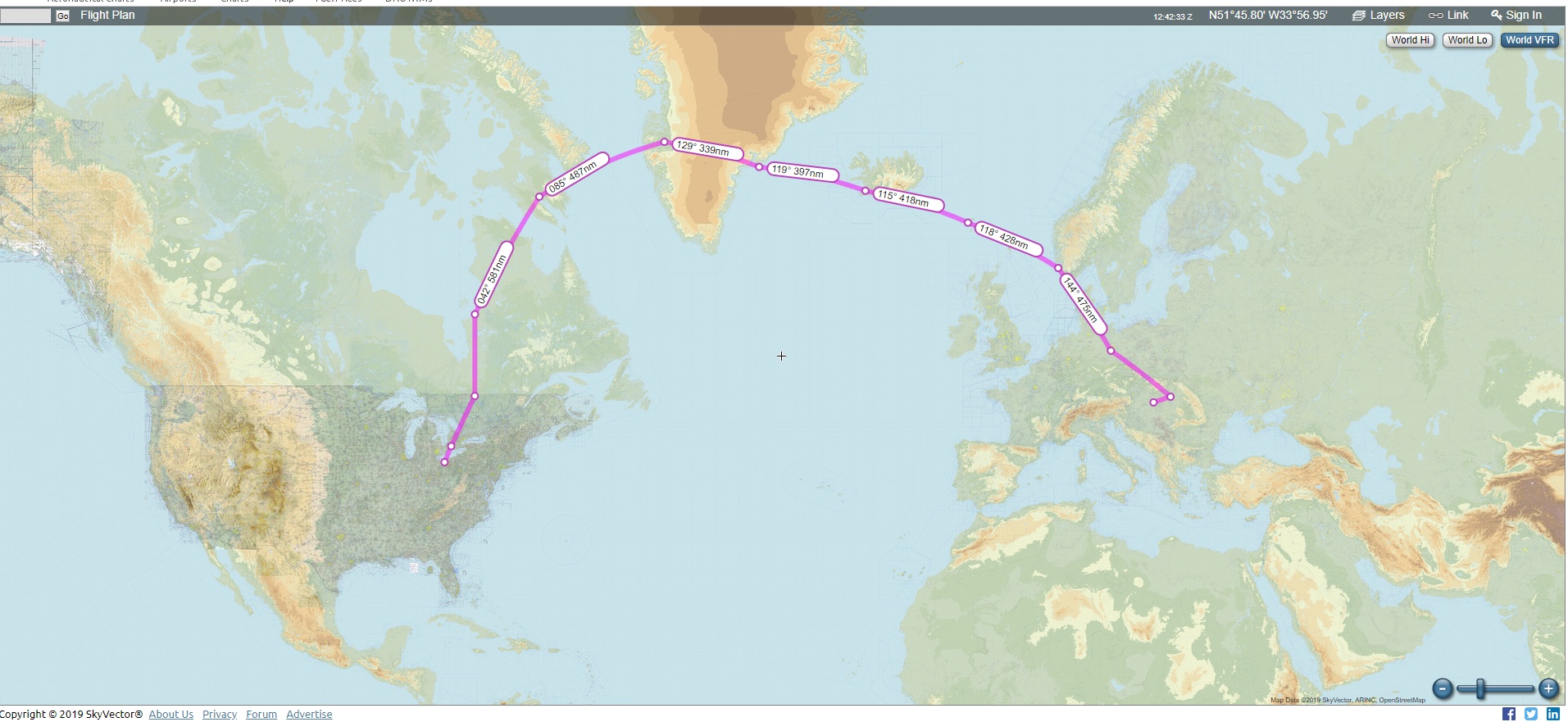
Departured on June 29. First leg was from Elyria, Ohio to London Ontario to clear customs. Of course, I filed an ICAO IFR flight plan. Before departure I submitted an eAPIS form with US customs, which took care of my US departure. Then I called CANPASS for the Canadian entry. They took my pilot info and asked me to call them on landing. So I did and received a number from them, which is a reference number for staying in Canada, and that was it, no agent visit, nothing. I think, this looks a lot more intimidating on paper than what it really is.
By the way, the airplane will need a radio station license in Canada.
Nobody asked me about this, but it still is the law. The FCC issues them for about $150+. Also, a
customs sticker is needed on a US registered airplane, but that is only for
returning to the USA.
FLIGHTPLAN: 1.13 hours
RV, then DCT
I filed my ICAO flight plan on the NAVCANADA website. London is a very nice airport with a tower. Also the airport has a very good restaurant.
FLIGHTPLAN: 3.3 hours
London2 departure, AGDUT, YEE, Destination
Leaving Val d'Or soon I entered uncontrolled air space. Most of the airspace is uncontrolled below 18000 feet. Pretty soon I was flying in IMC, under an IFR flight plan, but no radar control, nor any controller to talk to. The system works on a CTAF basis, so self announcement is essential. The only caveat to this is that there are no cities or anything to relate your position to. So, 80 miles south of CYGW, position report can not pinpoint you or other traffic. Another important note is that a lot of traffic announcement is in french. The CTAF requency is 126.7 Since a vast area is uncontrolled, the best strategy is to fly in and out of controlled air space as filed, then either fly above or below the clouds if possible. Left/right weather deviation is obviously necessary. In my case, I noticed that the clouds are getting darker and darker, so I turned out toward the Hudson Bay for a few miles. I heard on the radio someone mentioning isolated thunderstorms.
I pressed on the first day, as there was still plenty of daylight and the weather was nice and clear in Val d'Or.
As close as 10 miles out I already saw thick fog moving in to CYGW. Luckily I managed to land before the fog settled in, but it was a very unnerving approach, considering the thick fog. There has to be a relay station at CYGW, because I could talk to La Grande, and they took care of cancelling my IFR, and opening it the next day. However, the controlled area is about a 20 mile radius, I believe
In CYGW the Hotel is right across the street from the airport. The hotel front door is locked, and there is no reception desk or person there. The way it works is to call a number that is posted on the front door, and make arrangements and payment through the phone. Then they give you a number that is good for the front door to enter the hotel, and another number that is good for the keypad to enter your room. Unfortunately my Verizon phone was not working in Kuujuarapik, but luckily, Martin, a canadian pilot helped me out with this. By the way, the airport is fenced in, so there is no way in and out, except through security or through the staff access. Next to the airport and the Hotel there is a very small diner/restaurant. The staff working there were very nice.
FLIGHTPLAN: 4.4 hours
Direct at 11000'
CYGW sells avgas in 50 (US) gallon drums, but they DO NOT HAVE fuel pump or hose to get the fuel into the airplane. So a 6 foot garden hose is better than nothing. I purchased a small hand pump, back in the US, but soon it turned out it had a very low transfer volume, so in essence it was only a toy, not good enough to transfer 50 gallons. I don't know if they have aviation oil. I carried a case and three quarts of oil with me for the trip.
I left CYGW in relatively low ceiling and fog, but in about 1500' I broke out to a beautiful clear day. As far as I could see it was clear, except over the Hudson Bay, and the coastal areas for about 5 - 8 miles inland.
The scenery is simply stunning. It is beautiful and wild. There are a million lakes, rivers, water falls, mountains, with jagged rocks. Wonderful place. I flew a direct line to CYFB. On the way, still over land I put on the immersion suit. There are ice floes in the water, so it is safe to asume that it is very cold and the outlook for survival there is nill without an immersion suit.
Iqaluit has a working tower, but again, they are called a "radio". Their role seemed like a mix between a flight service station and approach/departure. They do not give clearance, but still manage traffic. The airport has an FBO between the main terminal and the tower, but the FBO does not sell fuel, only services. For me that is useless, so I just walked down the ramp to the fuel station and asked them to get me fuel. Despite the airport being a major jumping point over to Europe, they too sell fuel from drums - but at least they have a pump! By the way, the fuel guys here are awesome! They helped me find lodging, because I happened to arrive on Canada day and all the hotels were full. I got a room in Accomodations By The Sea. This is at the end of the town, but it was a really nice place. Taxi was the mode of transportation and they have a fixed price to and from the airport.
FLIGHTPLAN: 5.6 hours
Direct at 11000'
My Verizon phone did not get any reception here either, luckily I had pretty good WiFi at the lodge: Accomodations By The Sea. I filed my flight plan again through NAVCANADA website.
The flight was beautiful clear till about 200 miles from Kangerlussuak. Over the ocean there is now VHF radio coverage, so I did not need to carry an HF radio. My first position report was at 59West longitude with Edmonton Center, then at crossing 62West. Then I was handed over to Nuuk radio and eventually Kangerlussuak approach. There, my reporting point was 90 miles west of the SF NDB. The airport is all the way in the fjord, I think about 80 miles from the coast line. The airport is huge on the south side and plenty of room where my airplane parked, so they had to drive me to and from the airplane, which did not leave me much time to pack, unpack. All air pressures are now reported in hecto Pascals and they call it "QNH". I made my own QNH table at home and laminated it. The other side of that table I put different performance numbers for the airplene at different RPMs and altitudes.
The airport staff drove me to the local FBO, where the customs officer came too. It was a very simple and pleasant border crossing. Really, nice people. I paid "handling" fee on leaving from here, but I think that is air traffic controll fee, not actual handling of the airplane. On landing at the FBO they asked me where I was heading next, and as soon as I told them, they were ready to file my flight plan. Luckily, I hesitated, because I was not sure of the weather. When I checked, my heart dropped, because there was a very strong low pressure front moving in from the Atlantic Ocean toward Kulusuk (BGKK). The winds were over 65+ knots in the BGKK METAR. So, that is why it is extremely important to remain collected and not let yourself being rushed. Those winds over that terrain produce severe turbulence - which, for a Cherokee 140, is uncontrollable weather. I had to stay 2 more days here to wait out for better weather there.
The hotel is right on the airport and was decent. The dining hall/cafeteria has always some food, so no reason to starve there. Everything in Greenland is extremely pricey. I walked around and climbed the surrounding mountains. The view is stunning and wild and beautiful. In the distance you can see the ice cap.
In Kangerlussuaq, in the hotel cafeteria, I ran into a search and rescue Sikorski helicopter pilot. We talked quite a bit of aviation. He was pretty surprised that I flew there in a Cherokee 140. In his words, "you gotta know something to get in here". That was the best compliment I could have ever asked for - especially coming from a search and resuce pilot from Greenland! Anyway, he also warned me about Kulusuk ... he showed me pictures of not so lucky, or diligent, pilots who did not make it to the Kulusuk airport. There are a lot of crows and ravens in Greenland and Canada. They are carnivores, the rest I leave it to your imagination - but the pictures were not pretty. So, study the approach plates, and fly the numbers, there is no margin of error here.
FLIGHTPLAN: 4.8 hours
Iqaluit 5 Departure reporting crossing 62West
Departure was uneventful, but with a very steep climb as the mountains surrounding BGSF are tall. Soon I was flying over the greenland ice cap. The view there is astonishingly beautiful. First of all the ice is not a single sheet, but looks like broken up ice, with crevices everywhere. Then, there are big and small lakes on top of the ice cap with very deep blue color. Many of the lakes are connected by smaller streams and rivers. The minimum safe altitude here is 12000'. The density altitude here was so low, that my Cherokee 140 made it this high with relative ease. It was a bit hazy this close to the ice, so I climbed and cruised at 13000' all the way to Kulusuk. I used oxygen with the minimal 0.5l setting and that was more than enough. In fact, I did not feel any difference with or without oxygen.
I noticed Kulusuk airport a bit late, was only 15 miles out still at 13000'. The airport is on an island at the base of a tall mountain on the south, south-east side of the airport. Since I was still at a very high altitude, I had to do a steep 360 degree turn and slipped about 5000' too. There were ice floes everywhere in the water.
The airport is gravel and approaching from the west it has a significant descent angle, so better to put the plane down early and brake soon. This airport has a very, very dangerous surrouding. Go around would be very tricky as at the end of the runway, there is a narrow fjord and a steep mountain. So for a small airplane, the safe way is to make a sharp right turn at the end of the runway along the fjord, then a sharp left out towar the ocean. The approach is very tricky and dangerous in IMC. I purposely waited for VFR weather, and it was well worth it. Kulusuk is not for the faint hearted. They tied down my airplne with two 50 gallon drums filled with concrete - the winds are that fierce there.
The fuel and payment is handled up in the tower. I met Hans there, who later I met at the hotel again, and then we went for an evening walk with a couple of the hotel staff. The place is out of this world beautiful!
On landing, I noticed a smaller passenger plane on the ramp. Inside the terminal there were about 40+ people. Later, Hans told me that they were there only for a day tour, but the low pressure, that held me up in Kangerlussuak to fly in there, moved in way too fast. The pilot tried to radio the ice cave tours to get everyone back, but they did not arrive back to the airport soon enough. By then, the wind was so strong, that they could not depart. The hotel was full, so most of the passengers slept on the ground in the terminal.
FLIGHTPLAN: 3.5 hours
"WISK9" Departure, PEVAR, MASIK, DA
I cold not find that departure anywhere, so eventually I took off from BGSF and then I asked for an early turn, which they let me do.
Departure from Kulusuk, is very, very tricky toward the east. At the end of the runway there is a narrow fjord and on the other side a tall mountain. Because of my limited climb rate I elected to make a sharp right turn over the fjord, then, once I cleared the Kulusuk island, a sharp left turn to put me on course. Perhaps I could have cleared the mountains, but with the southerly winds, I could have gotten into some pretty strong mountain waves or turbulence on the lee side. The "S" turn option seemed the safest departure for my airplane.
There are periodic position reports, but it seemed like that it was in the controllers discretion where they wanted to have a position report. It was fairly easy, except for calculating the expected hour and minute for the next waypoint.
The flight was relatively uneventful, except for some mountain waves near Reykjavik. At some points it was difficult to hold altitude. This was a bit of a surprise, because the reported winds in Reykjavik were not that strong. I can imagine in strong winds, there is no way the Cherokee could maintain altitude.
In Reykjavik the customs were already waiting for me in the FBO. They were not as friendly as in Greenland, but, who cares, I got my stamp. The Hotel is right next to the runway, and is about a half hour walk from downtown Reykjavik. I walked everywhere and it was well worth it. The food in Iceland is fresh, no matter where I went. I have no idea where they get crisp fresh lettuce, because I never saw any farms or greenhouses, but they have fresh vegetables.
FLIGHTPLAN:3.9 hours
VAXAN, 6530N SOPEN RK at 11000'
The weather was faily nice about half way to Vagar, the Faroe Islands. Eventually, near Vagar, I had to face a thick layer of clours, but first I got into a hold over the MY NDB for a delayed departure. Vagar too is at the base of a high mountain and many mountains on the north side. Beacuse I was in IMC I was shooting a full approach, when suddenly on the outbound leg I ran into some broken layers and could see the airport. Took me a second, to realize that I could drop into one of the holes in the coulds instead of flying out 20 miles and then back. I asked to tower, and his answer was: "go for it". Cool controller ! So I made a steep 180, as there are mountains around, and then slipped the rest of the 5000' down to short final. The fjord on the north side of the runway acts like a funnel for the wind, so the final was quite turbulent. I felt like flying into a ventury tube. Lots of fun.
I parked very near the tower, at the north-west corner of the airport. Fueling here was a non-event. This airport is very well organized. I took a bus from the airport to Torshaven and stayed there the night. The city is so small, it can be easily walked around. Lovely little town, lovely scenery, nice people.
The line person at the FBO filed the flight plan for me here through Rocketroute.
FLIGHTPLAN: 4 hours
LUTER MOXAL, MY at 11000'
Left to the airport with the first bus. Beautiful VFR day on departure with stiff winds. Soon I ran into many layers of clouds, which slowly converged and ended up flying in IMC quite a bit, Winds were stronger over the ocean, but a lot calmer over Norway. I got vectors to final from my route so it was an easy fly in. I parked on the north-west corner on apron 13 where general avition is. Quite frankly nobody noticed that I arrived, so a local pilot called tower and they sent security for me, who drove me through customs, luggage checks and to the exit of the airport. I find it interesting that in Norway, they did not care what I brought in to the airport in my bags, but leaving, they X-rayed it.
There are a few hotels near the airport, so I just walked to one. The room was very clean, and fresh.
One of the staff at the airport helped me file my IFR flight plan through the Danish/Faroe aviation authority website
FLIGHTPLAN: 4 hours
LUVEK, GUNPA, KUNEM at 11000'
Stavanger is a major airport. I could not find and FBO there. There is a local flight club and briefly I ran into a pilot on arrival. Apparently, they call the tower to get in or out of the airport. Since there was no help here I purchased Rocketroute and used it on my Samsung phone. This program is a bit pricey, but worked really nicely, after hours and hours of frustrating setup and configuration. They have all kinds of acronyms and abbreviations that I have never heard in life - ever. I guess that is the european way of overcomplicating everything. Even after setup, every time the program complained that I have too much fuel. Yeah, because I had an auxiliary tank. Anyway, entering an origin and a destination will eventually return a preferred route from Eurocontrol. Filing is as easy as pressing a button.
The legal disasters:
Norway is not in the EU, only a schengen country. Flying to Mainz Finthen airport was an unknown mistake. I was convinced that Schengen you can travel borderless, and therefore I was not concerned. Yet on arrival at EDFZ, the controller said that I was in trouble, because I did not notify border patrol and customs. Eventually, she talked to Frankfurt and they said I was free to leave. The next day, however I was held up an hour and a half waiting for customs to arrive and talk to me. First thing they asked the valuue of the airplane. Second they said that I flew there, instead of an airport of entry because I wanted to import the airplane in the EU illegally and landed there to avoid the VAT taxes. So, valued my 1966 Cherokee 140 at 50000 euros. According to that price, they charged me the VAT tax with a total 8476.48 Euros - in cash. Since I did not have it, they asked me first how much I have. I did not give them anything, so they confiscated the airplane. The next day, I charged that amount to me credit card, but by the time I was done, huge thunderstorms rolled in to the entire western Germany, so I got grounded for two more days. Apparantly there are a lot of legal issues going on that the average pilot may not be aware of. First of all, Customs and Border protection are two separate agencies in germany. Border protection let me go, customs fined me. Second, they wanted money out of me under illegal import charges. Ver, very bad custom service, to
I had a pretty nice flight over the North Sea all the way till the Danish coast line, but then I ran into multiple cloud layers. eventually I flew at 13000', skimming the cloud tops, and picking up ice each time.
European flight plans are a marathon. They have every waypoint they can cram in there. Luckily, the controllers are very good and gave me a lot of shortcuts.
FLIGHTPLAN: 5.2 hours
BIVKI1 Departure BIVKI ENUPI EKMOL KUGAL LEGPI N873 WELGO CORIS NIMDO NIKIL DOBAK PARYD LINTU IBAGU T912 MIGTO DOMEG DEGOM MONAX RAMOB RUDUS VFR DCT
Leaving Germany was a major relief! I felt so hapy flying again and be able to complete my trip. The trip was uneventful except for catching up with the remnants of the previous days storm clouds. I picked up ice again at 13000' but at this point I was already over Slovakia, and getting ready to descend to lower altitudes. The approach to Budapest was an awesome feeling. I was home. The FBO in Budapest is at the western end of the airport by runway 13R-31L, called Ferihegy 1. Nice place.
FLIGHTPLAN: 3.8 hours
This was a very short flight
FLIGHTPLAN: 1 hour
BP641 NORAH
..... more to come for the return route
| Contact |
|
 lastname first initial @ tinkershop.net
Tel: : . ::: :: ::: ::::. :::: ::: :: :.
                   lastname first initial  @  tinkershop.net
                  Tel:      :  .  :::  ::  :::  ::::.  :::: ::: :: :.